El huracan Joaquin se fortalece y de acuerdo al ultimo boletin del Centro Nacional de Huracanes su trayectoria lo situa entrando por Carolina del Sur y afectado toda la parte del NortEste de Estados Unidos como muestran los mapas de su trayectoria…
Los vientos maximos sostenidos alcanzan las 120 millas por hora
BULLETIN
HURRICANE JOAQUIN ADVISORY NUMBER 14
NWS NATIONAL HURRICANE CENTER MIAMI FL AL112015
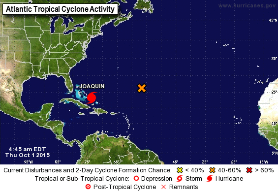
500 AM EDT THU OCT 01 2015
…MAJOR HURRICANE JOAQUIN WILL BATTER THE CENTRAL BAHAMAS WITH
HURRICANE FORCE WINDS…STORM SURGE…AND HEAVY RAIN THROUGH
TONIGHT…

SUMMARY OF 500 AM EDT…0900 UTC…INFORMATION
———————————————-
LOCATION…23.4N 73.7W
ABOUT 20 MI…35 KM N OF SAMANA CAYS BAHAMAS
ABOUT 65 MI…105 KM SE OF SAN SALVADOR BAHAMAS
MAXIMUM SUSTAINED WINDS…120 MPH…195 KM/H
PRESENT MOVEMENT…WSW OR 240 DEGREES AT 5 MPH…7 KM/H
MINIMUM CENTRAL PRESSURE…948 MB…27.99 INCHES
WATCHES AND WARNINGS
——————–
CHANGES WITH THIS ADVISORY:
None.
SUMMARY OF WATCHES AND WARNINGS IN EFFECT:
A Hurricane Warning is in effect for…
* Central Bahamas
* Northwestern Bahamas including the Abacos, Berry Islands,
Eleuthera, Grand Bahama Island, and New Providence
A Hurricane Watch is in effect for…
* Bimini
* Andros Island
A Tropical Storm Warning is in effect for…
* Southeastern Bahamas excluding the Turks and Caicos Islands
* Andros Island
A Hurricane Warning means that hurricane conditions are expected
somewhere within the warning area. Preparations to protect life and
property should be complete in the central Bahamas.
A Hurricane Watch means that hurricane conditions are possible
within the watch area.
A Tropical Storm Warning means that tropical storm conditions are
expected somewhere within the warning area.
For storm information specific to your area, please monitor products
issued by your national meteorological service.
DISCUSSION AND 48-HOUR OUTLOOK
——————————
At 500 AM EDT (0900 UTC), the center of Hurricane Joaquin was
located near latitude 23.4 North, longitude 73.7 West. Joaquin is
moving toward the west-southwest near 5 mph (7 km/h), and this
motion is expected to continue today. A turn toward the west-
northwest is forecast tonight, followed by a turn toward the north
and an increase in forward speed on Friday. On the forecast track,
the center of Joaquin will move near or over portions of the
central Bahamas today and tonight and pass near or over portions of
the northwestern Bahamas on Friday.
Maximum sustained winds are near 120 mph (195 km/h) with higher
gusts. Joaquin is a category 3 hurricane on the Saffir-Simpson
Hurricane Wind Scale. Some strengthening is forecast in the next
day or so, with some fluctuations in intensity possible on Friday.
Hurricane force winds extend outward up to 35 miles (55 km) from the
center and tropical storm force winds extend outward up to 140 miles
(220 km).
The estimated minimum central pressure is 948 mb (27.99 inches).