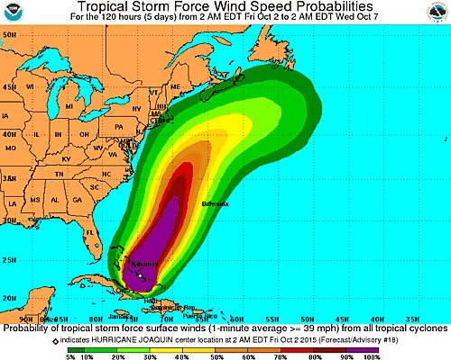
El Ultimo boletin del Centro National de Huracanes en Miami sobre el Huracan Joaquin hoy de categoria 4…informa que esa tormenta que pasa sobre las Bahamas se desviaria hacia el nort-oeste del Atlantico, pasando muy cerca de tierra en el Nort-este de Estados Unidos….
De todas se formas se pide a la comunidad estar atentos a los informes permanentes y la evolucion en el recorrido de Joaquin…que tiene maximos vientos sostenidos de 130 MPH….
BULLETIN
HURRICANE JOAQUIN ADVISORY NUMBER 18
NWS NATIONAL HURRICANE CENTER MIAMI FL AL112015
500 AM EDT FRI OCT 02 2015
…EXTREMELY DANGEROUS JOAQUIN MOVING SLOWLY NORTHWESTWARD AS IT
BATTERS THE CENTRAL BAHAMAS…
…HURRICANE CONDITIONS TO CONTINUE OVER THE CENTRAL BAHAMAS
TODAY…
SUMMARY OF 500 AM EDT…0900 UTC…INFORMATION
———————————————-
LOCATION…23.3N 74.7W
ABOUT 20 MI…35 KM NE OF CLARENCE LONG ISLAND BAHAMAS
ABOUT 50 MI…80 KM SSW OF SAN SALVADOR
MAXIMUM SUSTAINED WINDS…130 MPH…215 KM/H
PRESENT MOVEMENT…NW OR 315 DEGREES AT 3 MPH…6 KM/H
MINIMUM CENTRAL PRESSURE…935 MB…27.61 INCHES
WATCHES AND WARNINGS
——————–
CHANGES WITH THIS ADVISORY:
None.
SUMMARY OF WATCHES AND WARNINGS IN EFFECT:
A Hurricane Warning is in effect for…
* Central Bahamas
* Northwestern Bahamas including the Abacos, Berry Islands,
Eleuthera, Grand Bahama Island, and New Providence
* The Acklins, Crooked Island, and Mayaguana in the southeastern
Bahamas
A Hurricane Watch is in effect for…
* Bimini
* Andros Island
A Tropical Storm Warning is in effect for…
* Remainder of the southeastern Bahamas including the Turks and
Caicos Islands
* Andros Island
* Cuban provinces of Camaguey, Los Tunas, Holguin, and Guantanamo
A Hurricane Warning means that hurricane conditions are expected
somewhere within the warning area.
A Hurricane Watch means that hurricane conditions are possible
within the watch area.
A Tropical Storm Warning means that tropical storm conditions are
expected somewhere within the warning area.
Interests in Bermuda should monitor the progress of Joaquin. A
Tropical Storm or Hurricane Watch may be required later today.
For storm information specific to your area, please monitor
products issued by your national meteorological service.
DISCUSSION AND 48-HOUR OUTLOOK
——————————
At 500 AM EDT (0900 UTC), the center of Hurricane Joaquin was
located near latitude 23.3 North, longitude 74.7 West. Joaquin is
drifting toward the northwest near 3 mph (6 km/h). A faster
northward motion is expected to begin later today, followed by a
turn toward the northeast and an increase in forward speed tonight
and Saturday. On the forecast track, the core of the strongest winds
of Joaquin will continue moving over portions of the central and
northwestern Bahamas today. Joaquin will begin to move away from the
Bahamas tonight and Saturday.
Maximum sustained winds are near 130 mph (215 km/h) with higher
gusts. Joaquin is a dangerous category 4 hurricane on the Saffir-
Simpson Hurricane Wind Scale. Some fluctuations in intensity are
possible during the next 24 hours. Slow weakening is expected to
begin on Saturday.
Hurricane force winds extend outward up to 50 miles (85 km) from the
center and tropical storm force winds extend outward up to 205 miles
(335 km).
The estimated minimum central pressure is 935 mb (27.61 inches).


