BOLETÍN
Aviso especial sobre la tormenta tropical Gordon número 4
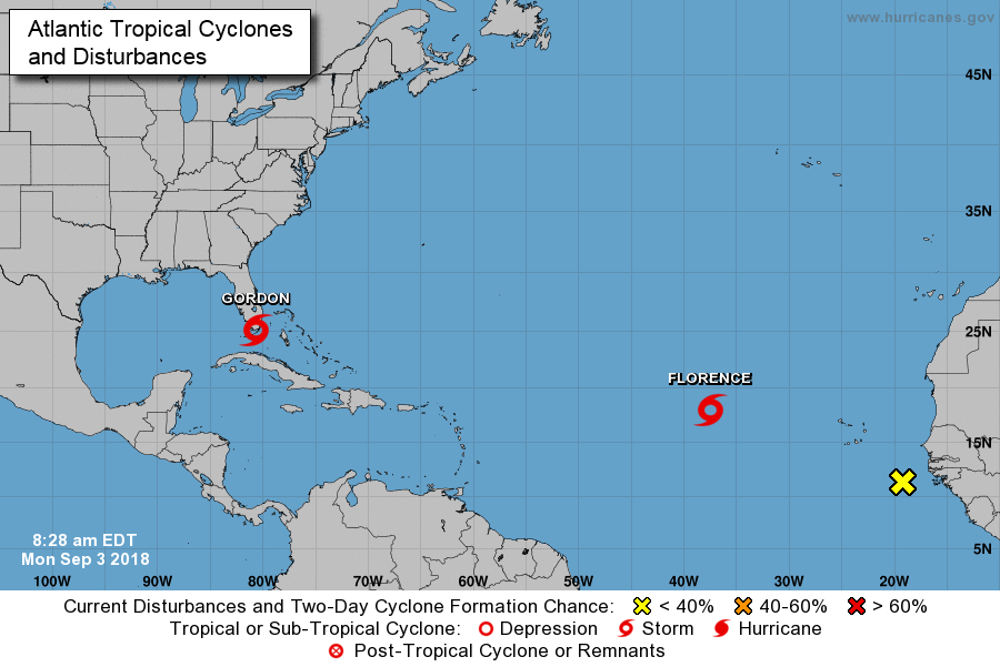
Centro Nacional de Huracanes NWS Miami FL AL072018
830 a.m. EDT lun. Sep. 03 2018
... TORMENTA TROPICAL GORDON FORMS SOBRE LAS CLAVES SUPERIORES DE LA FLORIDA ...
... ADVERTENCIAS SOBRE TORMENTAS TROPICALES EMITIDAS POR PARTES DEL SUR DE LA FLORIDA
Y LAS LLAVES DE LA FLORIDA CON FUERTES LLUVIAS PROBABLES ...
RESUMEN DE 830 AM EDT ... 1230 UTC ... INFORMACIÓN
----------------------------------------------
UBICACIÓN ... 25.1N 80.7W
ACERCA DE 20 MI ... 30 KM W DE KEY LARGO FLORIDA
ACERCA DE 85 MI ... 135 KM SE DE MARCO ISLAND FLORIDA
VIENTOS MAXIMOS SOSTENIDOS ... 45 MPH ... 75 KM / H
MOVIMIENTO ACTUAL ... NOVEDAD O 300 GRADOS A 17 MPH ... 28 KM / H
PRESIÓN CENTRAL MINIMA ... 1009 MB ... 29.80 PULGADAS
RELOJES Y ADVERTENCIAS
--------------------
CAMBIOS CON ESTA ADVERTENCIA:
Se ha emitido una advertencia de tormenta tropical para partes del sur
Florida desde Golden Beach a Bonita Beach y Florida
Llaves de Craig Key a Ocean Reef, incluida Florida Bay.
RESUMEN DE RELOJES Y ADVERTENCIAS EN EFECTO:
Un Storm Surge Watch está en efecto para ...
* Frontera Mississippi-Alabama hacia el oeste hasta la desembocadura del
río Mississippi
Una advertencia de tormenta tropical está en vigor para ...
* Playa dorada a Bonita Beach
* Clave de Craig para Ocean Reef, incluida Florida Bay
* Frontera Alabama-Florida hacia el oeste al este de Morgan City, Louisiana,
incluyendo el lago Pontchartrain y el lago Maurepas
Una advertencia de tormenta tropical significa que las condiciones de tormenta tropical son
esperado en algún lugar dentro de las áreas de advertencia.
Para obtener información sobre tormentas específica para su área, incluyendo posible
Relojes y advertencias en el interior, controle los productos emitidos por su
oficina local de pronóstico del Servicio Meteorológico Nacional.
WTNT32 KNHC 031227 TCPAT2 BULLETIN Tropical Storm Gordon Special Advisory Number 4 NWS National Hurricane Center Miami FL AL072018 830 AM EDT Mon Sep 03 2018 ...TROPICAL STORM GORDON FORMS OVER THE UPPER FLORIDA KEYS... ...TROPICAL STORM WARNINGS ISSUED FOR PORTIONS OF SOUTH FLORIDA AND THE FLORIDA KEYS WITH HEAVY RAINS LIKELY... SUMMARY OF 830 AM EDT...1230 UTC...INFORMATION ---------------------------------------------- LOCATION...25.1N 80.7W ABOUT 20 MI...30 KM W OF KEY LARGO FLORIDA ABOUT 85 MI...135 KM SE OF MARCO ISLAND FLORIDA MAXIMUM SUSTAINED WINDS...45 MPH...75 KM/H PRESENT MOVEMENT...WNW OR 300 DEGREES AT 17 MPH...28 KM/H MINIMUM CENTRAL PRESSURE...1009 MB...29.80 INCHES WATCHES AND WARNINGS -------------------- CHANGES WITH THIS ADVISORY: A Tropical Storm Warning has been issued for portions of South Florida from Golden Beach to Bonita Beach, and for the Florida Keys from Craig Key to Ocean Reef, including Florida Bay. SUMMARY OF WATCHES AND WARNINGS IN EFFECT: A Storm Surge Watch is in effect for... * Mississippi-Alabama border westward to the Mouth of the Mississippi River A Tropical Storm Warning is in effect for... * Golden Beach to Bonita Beach * Craig Key to Ocean Reef, including Florida Bay * Alabama-Florida border westward to east of Morgan City, Louisiana, including Lake Pontchartrain and Lake Maurepas A Tropical Storm Warning means that tropical storm conditions are expected somewhere within the warning areas. For storm information specific to your area, including possible inland watches and warnings, please monitor products issued by your local National Weather Service forecast office. DISCUSSION AND OUTLOOK ---------------------- At 830 AM EDT (1230 UTC), the center of Tropical Storm Gordon was located by NOAA Doppler weather radar and surface observations near latitude 25.1 North, longitude 80.7 West. Gordon is moving toward the west-northwest near 17 mph (28 km/h) and a west- northwestward to northwestward motion is expected over the next 72 hours. On the forecast track, the center of Gordon will pass over the southern tip of the Florida peninsula this morning, move over the southeastern Gulf of Mexico this afternoon and evening, and reach the warning area along the central Gulf Coast by late Tuesday or Tuesday night. Surface observations and radar data indicate that maximum sustained winds have increased to near 45 mph (75 km/h) with higher gusts. Additional strengthening is forecast during the next 48 hours. Tropical-storm-force winds extend outward up to 45 miles (75 km) from the center. The estimated minimum central pressure is 1009 mb (29.80 inches). HAZARDS AFFECTING LAND ---------------------- STORM SURGE: The combination of a dangerous storm surge and the tide will cause normally dry areas near the coast to be flooded by rising waters moving inland from the shoreline. The water could reach the following heights above ground somewhere in the indicated areas if the peak surge occurs at the time of high tide... Destin Florida to the Mississippi-Alabama border...1 to 2 ft. Mississippi-Alabama border to the Mouth of Mississippi River...2 to 4 ft Mouth of the Mississippi River to the Louisiana-Texas border...1 to 2 ft The deepest water will occur along the immediate coast near and to the east of the landfall location, where the surge will be accompanied by large waves. Surge-related flooding depends on the relative timing of the surge and the tidal cycle, and can vary greatly over short distances. For information specific to your area, please see products issued by your local National Weather Service forecast office. RAINFALL: Gordon is expected to produce total rain accumulations of 2 to 4 inches over the central and northwestern Bahamas, the Florida Keys, and South Florida through early Tuesday. Isolated maximum amounts of 8 inches are possible over the southern Florida peninsula. Gordon is expected to produce total rain accumulations of 4 to 6 inches over southern Alabama, southern Mississippi and Louisiana, with isolated maximum amounts of 8 inches through early Thursday. These rainfall amounts may cause flash flooding. WIND: Tropical storm conditions are occurring in the warning areas across South Florida and the Florida Keys, and those conditions should continue through the afternoon. Tropical storm conditions are expected within portions of the central Gulf Coast warning area by late Tuesday. NEXT ADVISORY ------------- Next complete advisory at 1100 AM EDT. $$ Forecaster Stewart

nhc.nooa.gov