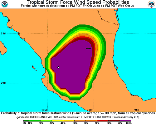
El ultimo boletin del Centro Nacional de Huracán reporta que Patricia considerado el fenomeno mas poderoso en los ultimos 50 años en la historia Mexicana, perdio categoria despues de entrar por las costas del Pacifico de esa nacion y ahora se redujo a Tormenta Tropical….de los vientos sostenidos de hasta 200 MPH, ahora sus vientos maximos sostenidos a las 75 MPH….moviendose en direcccion norte, Nort-este.
Las principales preocupaciones en la actualidad pasan por el trafico aéreo, muy afectado desde hace dos dias y las inundaciones….
Hurricane PATRICIA Public Advisory
Home Public Adv Fcst Adv Discussion Wind Probs Graphics Archive
000
WTPZ35 KNHC 240832
TCPEP5
BULLETIN
HURRICANE PATRICIA ADVISORY NUMBER 18
NWS NATIONAL HURRICANE CENTER MIAMI FL EP202015
400 AM CDT SAT OCT 24 2015
…PATRICIA RAPIDLY WEAKENING OVER MEXICO…
…HEAVY RAINS CONTINUE…
SUMMARY OF 400 AM CDT…0900 UTC…INFORMATION
———————————————-
LOCATION…22.3N 103.1W
ABOUT 50 MI…80 KM…SSW OF ZACATECAS MEXICO
ABOUT 130 MI…205 KM ENE OF TEPIC MEXICO
MAXIMUM SUSTAINED WINDS…75 MPH…120 KM/H
PRESENT MOVEMENT…NNE OR 25 DEGREES AT 21 MPH…33 KM/H
MINIMUM CENTRAL PRESSURE…986 MB…29.12 INCHES
WATCHES AND WARNINGS
——————–
CHANGES WITH THIS ADVISORY:
The government of Mexico has discontinued the Tropical Storm
Warning west of Manzanillo.
SUMMARY OF WATCHES AND WARNINGS IN EFFECT:
A Tropical Storm Warning is in effect for…
* Manzanillo to Lazaro Cardenas
A Tropical Storm Warning means that tropical storm conditions are
likely occurring within the warning area.
For storm information specific to your area, please monitor
products issued by your national meteorological service.
DISCUSSION AND 48-HOUR OUTLOOK
——————————
At 400 AM CDT (0900 UTC), the center of Hurricane Patricia was
located near latitude 22.3 North, longitude 103.1 West. Patricia is
moving toward the north-northeast near 21 mph (33 km/h). Patricia is
forecast to move quickly north-northeastward farther inland over
northern and northeastern Mexico today.
Maximum sustained winds have decreased to near 75 mph (120 km/h)
with higher gusts. Rapid weakening is expected to continue, and
Patricia is forecast to become a tropical storm later this morning,
and dissipate tonight.
Hurricane-force winds extend outward up to 25 miles (35 km) from the
center and tropical-storm-force winds extend outward up to 290 miles
(465 km).
The estimated minimum central pressure is 986 mb (29.12 inches).


